探究机载LiDAR技术在复杂矿区储量估算中的支持作用

打开文本图片集
中图分类号:TD802 文献标志码:A 文章编号:1001-5922(2026)03-0814-04
Explore the supporting role of airborne LiDAR technology in reserve estimation of complex mining areas
CHENG Yu,TIAN Meng (1.The First Geological Brigade of Jiangsu Provincial Geological Bureau,Nanjing 21OO41,China; 2. Jiangsu Nanjing Geological Engineering Survey Institute Co. ,Ltd. ,Nanjing 21OO41,China)
Abstract:This paper discusses the application value of airborne LiDAR technology in high-precision terrain modeling and mineral reserve estimation in complex mining areas. Centering on the composition of LiDAR system,data acquisitionand processing flow,asetof digital terrain modeling method for complex terrain isestablished.Combined with typical mining area cases,reserve estimation practice is caried out by means of 3D terrain analysis and ore body boundary identification,and the model accuracy is verified.The results show that airborne LiDAR can significantlyimprove theaccuracyand eficiencyof terrainmodelingand stillhasgoodadaptabilityunder complex geomorphic conditions.
Key words :airborne liDAR ; mining area modeling;digital terrain model;reserve estimation;3D terrain analysis
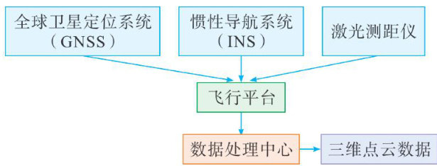
复杂矿区地形起伏剧烈、植被覆盖不均,传统测量手段难以快速获取高精度地形信息,影响地形建模与储量估算的准确性。(剩余6281字)