多时相基础测绘数据在土地利用动态监测中的应用效果对比分析

打开文本图片集
中图分类号:P237 文献标志码:A 文章编号:2095-2945(2026)08-0077-04
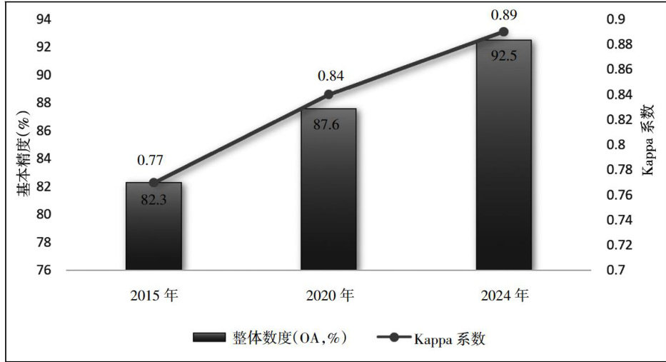
Abstract:Toevaluatethe practical efectofmulti-temporal basicsurveyingandmapping datainthe dynamic monitoringof landuse,thisstudyselectsthesuburbsofacertaincityastheresearchbackgroundandconductsin-depthcomparativeanalysis byusingremotesensingclasificationmapsfrom2015,2020,and2024,combinedwiththedatafromfeldinvestigations.The accuracy of classification has been increasing every year, from 82.3% in 2015 to 92.5% in 2024. The significant increase in the area of construction land +8.4km2 )mainly results from the conversion of cultivated land. Experiments have proved that highresolutionandhighlytimelydatahaveastrongabilitytoidentifylandusechangesandaresuitablefortheconstructionofa dynamic monitoring system in urban expansion areas.
Keywords:multi-temporalsurveying and mapping;;landusechange;clasificationaccuracy;transfermatrix;dynamic monitoring
土地利用变化作为城市化和生态演变过程中的重要体现,精确监测土地利用变化动态对规划和管理具有重要意义。(剩余6873字)