“一带一路”岛屿国家海洋空间规划合作路径研究

打开文本图片集
中图分类号:P748;F125.5 文献标志码:A 文章编号:1005-9857(2025)10-0049-10
Abstract:Marine Spatial Planning(MSP)has been implemented in many countries worldwide and has become a key topic in international exchanges and cooperation. Island countries along the Belt andRoad Initiative(BRI) possess unique geographical locations and abundant marine spatial resources,giving them a special role in global ocean governance.With the introduction of the“Vision for Maritime Cooperation under the Belt and Road Initiative,”strengthening MSPcooperationbetween Chinaand BRI island nations has become a crucial step in advancing high-qualityBeltand Road cooperation.Througha SWOTanalysis of international MSPcolaboration, it is proposed that China adopta“combining focal points with broader outreach”strategy in MSPcooperation with BRI island countries.This involves identifying key partner countries and creating demonstration cases by following a pathway of“consolidating relations-prioritizingcooperation-tailoring country-specific policiesselecting partner countries-reaching intentions-formulating plans.”Aditionally,it is essential to establish technical standards for formulating MSP in international cooperation and design a technical roadmap for plan development.Deepening sientific research collaboration willenhance mutual trust,while promoting the blue economy will help meet the development needs of BRI island nations.
Keywords: Island states,Marine spatial planning,The Belt and Road,SWOT analysis
0 引言
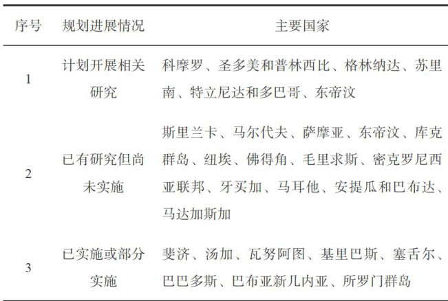
2017年6月,国家发展和改革委员会与国家海洋局联合发布了《“一带一路”建设海上合作设想》(以下简称《设想》。(剩余12166字)