长角融合空间坐标测量系统误差建模和标定

打开文本图片集
关键词:坐标测量;误差建模;误差标定;多目标
中图分类号:TH74 文献标识码:A
doi:10.37188/OPE.20253317.2704 CSTR:32169.14.OPE.20253317.2704
Modeling and calibration of system errors in distance-angle fusion spatial coordinate measurement
QU Haochen¹,WANG Na²,LI Dongwei², XU Qian², DENG Jiaopeng³,KAZEZKHAN Guljaina 2 ZHANG Xinpan³,WU Tengfeil*,SHI Shendong¹,ZHU Jigui1
(1.State Key Laboratory of Precision Measuring Technology and Instruments,Tianjin University, Tianjin 300072,China;
2. Xinjiang Astronomical Obseruatory, Chinese Academy of Sciences, Urumqi 83Ool1, China;
3. The 39th Research Institute of China Electronics Technology Group Corporation, (204号 Xi′ an 710065,China) * Corresponding author,E-mail: wtf@tju. edu. cn
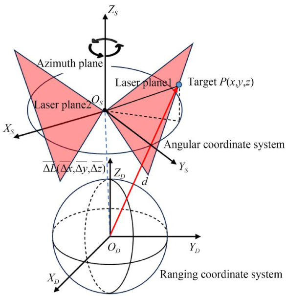
Abstract: Facing multi-objective,autonomous, parallel measurement demands in the manufacturing of high-end equipment (e.g.,aviation and aerospace)and the construction and operation of large scientific facilities(e.g.,large radio telescopes),improvements are presented for the distance-angle fusion spatial coordinate measurement system previously proposed. The geometric-structure eror model has been refined, and a high-precision control-field calibration method based on an adaptive weighted optimization algorithm is introduced.Precise calibration of the system's error parameters was achieved. In indoor calibration experiments,the average deviation of coordinates across 24 calibration points was 0.0981mm ,closely matching the theoretical average deviation from single-measurement simulation. In outdoor astronomical observation conditions,the standard deviation of point-position measurements for 1O observation points was better than 0.021mm ,the maximum tangential displacement comparison deviation of the reflective surface was 0.022mm ,and the maximum gravitational-direction displacement deviation was 0.040mm These results demonstrate that the proposed method efectively calibrates the error parameters of the distance-angle fusion coordinate measurement system and satisfies the real-time control requirements for active surface shape accuracy in astronomical observations.
Key words: coordinate measurement; error modeling;error calibration; multi-objective
1引言
空间三维坐标测量是刻画物体外形结构、描述物体位姿状态及相互关系的最基本、最常用的方法,也是机械制造保证产品质量、进行工艺控制的重要手段[1-3]。(剩余15344字)